The maps help you find military installations in your state, along with contact information for Exceptional Family Member Program (EFMP) Family Support or School Liaison Office (SLO) staff in each location. For Coast Guard and National Guard locations, we have contacts for the Special Needs Program (SNP) and the Family Assistance Coordinators, respectively. Contacts who support Recruiter families are also included
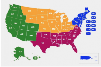
Scroll down to find the mini-map for your state.
- To open the map, click on the open square icon, which is in the upper right corner of each mini-map on this page.
- In the open map you can click on a colored icon for contact information, or use the side list. You can also drag the map along on this page by placing the cursor on the map and moving the cursor when it becomes a hand.
- For just the list of installations and contacts, click on the list icon at the top left of the mini-map. If it says something like “and 55 more”, click on that phrase to open the entire list.
- When the list opens, select the installation or contact you want; information opens in a new box.
- The map and list use Google Maps for you to get directions.
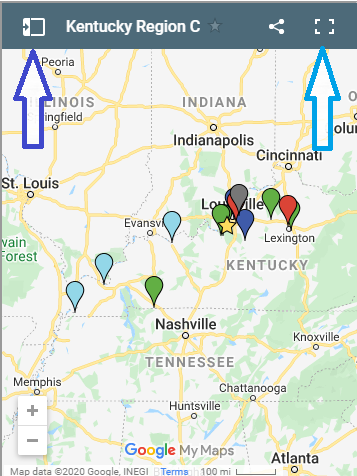
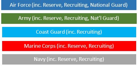
The map icons represent military locations and the yellow stars are Parent Centers. The key above the maps shows how the icons are color coded by branch. Air Force is dark blue, Army is green, Marine Corps is red, Coast Guard is light blue and the Navy is battleship gray.
Download map information as a Word docx.:
Connecticut Delaware District of Columbia Maine Maryland Massachusetts New Hampshire
New Jersey New York Pennsylvania Puerto Rico Rhode Island US Virgin Islands Vermont